In late 1939 the German cruiser Admiral Graf Spee went on a raiding journey in the South Atlantic and sunk 9 merchant vessels before encountering the Royal Navy cruisers Exeter, Ajax and Achilles and being cornered in Montevideo, Uruguay. In the middle of this journey, Captain Langsdorff of the Admiral Graf Spee took the ship around the southern tip of Africa and sunk the Africa Shell off the coast of Mozambique before doubling back and returning to the South Atlantic., hoping to confuse his opponents and put them off the chase.
Africa Shell, a smaller tanker of 706 tons, was sighted by the Admiral Graf Spee as it was heading south along the coast for its final destination of Lourenco Marques, still some 170 nautical miles (320 kilometres) away to the southwest. According to the captain of the Africa Shell, Patrick Dove, once the Admiral Graf Spee was sighted, the Africa Shell turned to towards the shoreline in the hopes of escaping into neutral waters. Mozambique was a Portuguese colony at the time and Portugal was officially neutral.
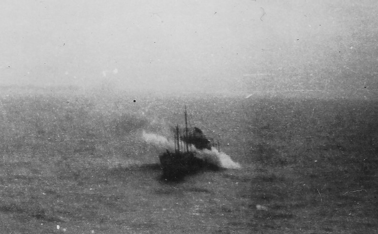
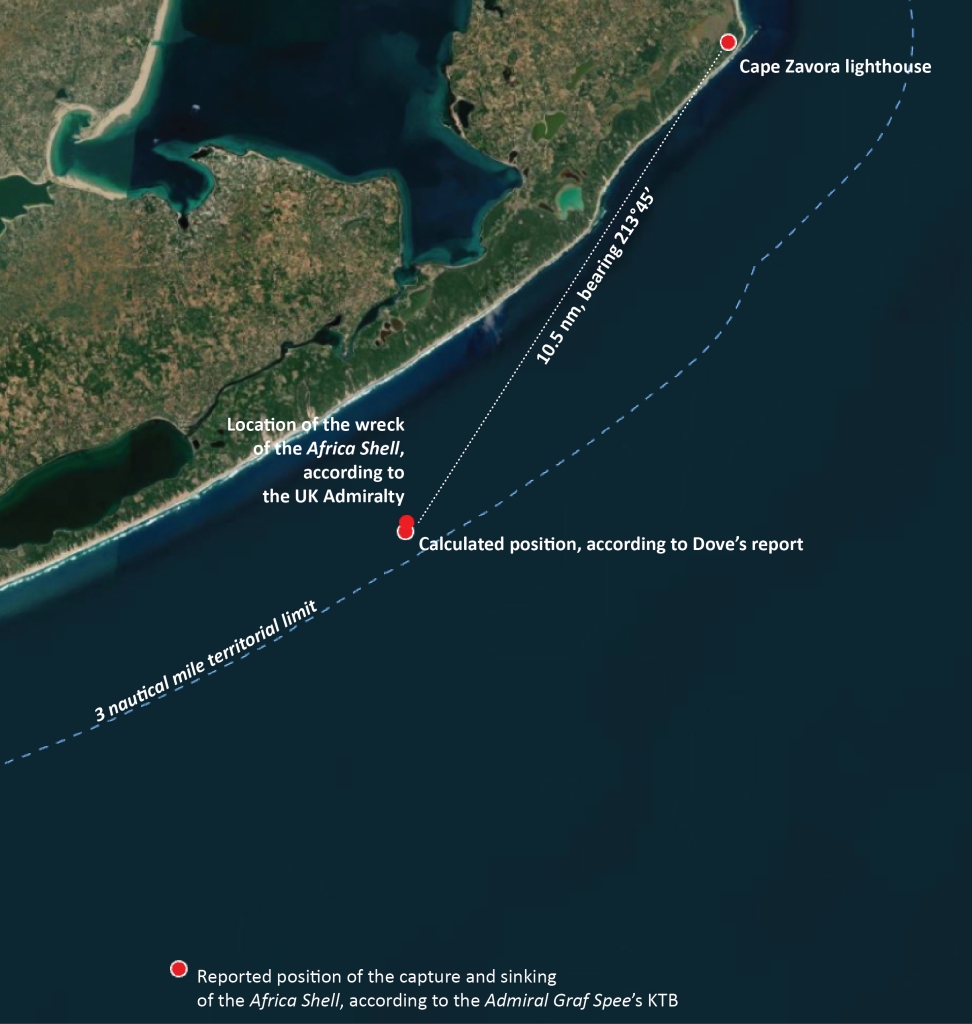
Dove writes in his book I Was Graf Spee’s Prisoner that his orders to his navigation officer “were to take the most careful bearings and make a full record of them on paper. I myself checked these bearings.”[1] He insists that the ship was a half mile within the 3 nautical mile limit. Elsewhere in his book he states that “according to the bearings taken by my second officer my position was ten-and-a-half miles southwest by south from Cape Zavora lighthouse, and my vessel was two-and-a-half miles from the shore, and therefore inside the territorial limits of Portuguese East Africa.”[2] The UK Admiralty’s database of wrecks and obstructions puts the location of the Africa Shell at 24° 40′ 00″ South 35° 30′ 03″ East, about 370 m from this location.
The Germans always maintained that the Africa Shell was captured and sunk outside the 3 mile nautical limit so it is no surprise that the location of these events is different in the Admiral Graf Spee’s Kriegstagebücher or war diary (KTB). There Captain Langsdorff of the Admiral Graf Spee records that on November 15, 1939 at 14:06, the Admiral Graf Spee captured and sunk the Africa Shell at 24° 48′ South, 35° 01′ East.[3] This is approximately 9.7 nautical miles (18 km) from Dove’s stated position and 8.4 nm (15.5 km) from the Mozambique shoreline.
Of course, location measurement wasn’t an exact science in 1939 as it is today with GPS units and cellphones that give you a fairly precise location. If the weather was rough or the skies overcast, it could be tough or impossible to take any reading. Even on a good day measurements using a sextant – the instrument of the time – were +/- a half mile or so. Dove and his navigator could easily have been off as might have the Admiral Graf Spee. On top of that, both parties were motivated to state the accuracy of their claim so some allowances might have been made.
To my knowledge, the exact location of the wreck of the Africa Shell has not been mapped. Doing so would go far in clarifying whether or not the ship was sunk within territorial waters. However, even if the ship was sunk within territorial waters, it would have been unlikely to have had much affect on events. The Portuguese government might have sent a letter of protest to the German government and the Germans might have at the most, made a half-hearted apology. In any case, by the time that would have happened, the Admiral Graf Spee would have long disappeared again into the South Atlantic.
[1] I Was Graf Spee’s Prisoner, Patrick Dove, Viking Press, 1956, p.93
[2] Ibid, p. 77.
[3] Kriegstabebuch des Kommandanten Kapitän zur See, Hans Langsdorff, p. 147
