The Month the Tonnage War was Lost

It’s debtable whether or not the Germans ever came close to winning the tonnage war in World War II. I personally don’t think so but more numbers would need to be collected including the construction records of Allied shipyards not in North America as well as a determination of how much shpping tonnage Britain would have needed to stay alive. However, after collecting the merchant shipping tonnage built by Canada and the United States during the Second World War and comparing that to what I have for Allied merchant shipping losses, it doesn’t seem likely. These 2 countries alone accounted for 37.7 million gross registered tons of shipping. What this number does not account for is the amount of shipping that became available to the Allies when the United States entered the war as well as any of the new construction that happened outside of North America. That, obviously, requires a bit more work to include.

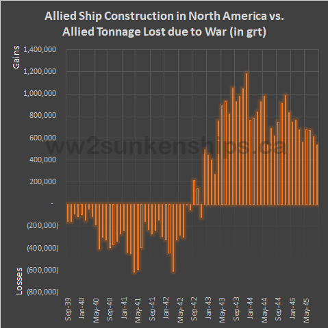
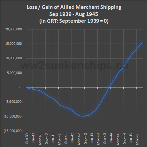
In the meantime, the first chart above compares the cumulative gains (new construction) and losses for the Allies for each month of the war. The two North American countries began to build ships faster than they could be sunk in Spetember, 1942 when 713,204 tons of new merchant shipping was delivered while 500,881 tons was lost due to war. With one exception, in every month from then on until the end of the war, Canada and the United States (the latter accounting for 93% of total war time production) easily replaced Allied losses. The German submarine arm’s Black May in which 41 of its boats were lost had yet to happen and was just the final nail in the coffin for the Germans.

Even so, it wasn’t until December 1943 that all Allied shipping losses since the beginning of the war were replaced with new construction (below).

August 2023 Updates

A slow month for updates.

Updates for this month:

  • 23 records edited (additional links, corrections)
  • 5 records moved to better locations
  • 1 record deleted
  • 3 new additions

The following vessels were added to the database:

  • Astrid, sunk September 17, 1942
  • Hans Broge, sunk June 15, 1941
  • Snark, sunk February 24, 1942 off Nouméa (read about it on Instagram)
Snark, when it was stilled named Olympia

Belgian Merchant Shipping Losses in World War II

The Belgian merchant ship Bruxelles, 5,085 tons, sunk on June 9, 1942

Belgium was a relatively minor player in the Second World War, both on land and on the sea. At the start of the war in September 1939, it boasted a merchant fleet of only 472,182 tons – well behind the UK, the undisputed world leader in shipping at the time with 16.6 million tons. In the period of September 1939 to May 1940 before Belgium was invaded by the Germans and the country joined the Allied cause it had already lost close 30,000 tons of shipping to accidents, mines and German torpedoes (even though it was officially neutral).

When Belgium surrendered to the Germans on May 28, 1940 only a small part of its merchant fleet fell into German hands – about 71,000 tons – while the majority – 358,000 tons – continued to serve the Allies. The Germans steadily whittled away at this disadvantage throughout the war so that by the end of the war, only about 108,000 tons of Belgian shipping in Allied control remained afloat. Of the 71,000 tons the Germans had captured, only 21,000 tons managed to survive the war. In the end, only 27% of the Belgian merchant fleet that existed at the start of the war survived to the end.

The sankey chart below provides a breakdown of the status of the Belgian fleet during the course of the war.

July 2023 Updates

Updates for this month:

  • 107 records edited (additonal links, spelling corrections)
  • 132 records moved to better locations
  • 5 records deleted
  • 27 new additions

The following vessels were added to the database:

  • Adjbi, sunk January 24, 1943 off the coast of Tunisia
  • Alessandro Volta, sunk March 22, 1943 off the coast of Sicily
  • British Inventor, sunk June 13, 1940 off the south coast of England
  • Cabedello, sunk February 25, 1942 in the middle Atlantic Ocean
  • Elisabeth, sunk April 7, 1941 off the south coast of England
  • Gladiator, sunk May 21, 1941off the coast of Croatia
  • Guglielmo Marconi, sunk January 20, 1943 off the coast of Tunisia
  • Intrepido, sunk October 26, 1940 off the coast of Libya
  • Irma, sunk January 20, 1943 off the coast of Libya
  • Istria, sunk August 27, 1942 between Libya and Crete
  • La Mora, sunk June 12, 1940 off the west coast of Italy
  • Lindbergh, sunk February 19, 1943 off the south coast of England
  • Listrac, sunk October 17, 1940 off the south coast of England
  • Littoria, sunk February 4, 1943 off the coast of Montenegro
  • Lodoletta, sunk August 3, 1940, off the coast of Libya
  • Madonna di Porto Salvo, sunk April 10, 1943 off the west coast of Italy
  • Mafalda, sunk January 31, 1945 off the west coast of Italy
  • Manfred Camperio, sunk Agust 27, 1942 west of Crete
  • Margottini, sunk February 10, 1943 off the coast of Montenegro
  • Maria G, sunk January 21, 1941 off the coast of Sardinia
  • Monginevro, sunk April 17, 1943 off the coast of Tunisia
  • Monti, sunk March 22, 1943 off the coast of Tunisia
  • Nereus, sunk March 25, 1941 off the coast of Sicily
  • Octaviano Augusto, sunk November 1, 1943 near Ancona, Italy (read about it on Instagram)
  • Rinova, sunk February 11, 1940 off the south coast of England
  • Savoia, sunk July 18, 1944 near Ancona, Italy (read about it on Instagram)
  • Stanwood, sunk December 10, 1939 off the south coast of England
The Italian liner Savioa in happier days

Visit the dashboard to see them all! Or use the Find-A-Ship app.

June 2023 Updates

Updates for the month:

  • 82 records edited (additional links, spelling corrections)
  • 150 records moved to better locations
  • 5 records deleted
  • 25 new additions

The following vessels were added to the database:

  • Carry On, sunk 17 December 1940, in the Thames Estuary
  • Duolio Cesare, sunk 10 July 1944, at Trieste – see it and read about it on Instagram
  • V 16 Filuccio, sunk 17 September 1941, west of Tripoli
  • Frankfurt, sunk 22 March 1945, in the Baltic Sea
  • Giorgio, sunk 24 Mrch 1943, off the west end of Sicily
  • Giovanni delle Bande Nore, sunk 5 May 1943, off the west end of Sicily
  • Giudecca, sunk 13 October 1944, near Venice
  • Giuseppe e Maria, sunk 9 November 1940, off the southern tip of Sicily
  • Grethe Mortensen, sunk 7 November 1944, off the Thames Estuary
  • No 56, Barometr, sunk 28 August 1941, in the Gulf of Finland
  • No 71 Krab, sunk 28 August 1941, in the Gulf of Finland
  • Lenin, on 24 June 1941, at Liepaja / Libau
  • M 1707 Lunenberg, sunk 17 September 1941, off the coast of Latvia
  • Monte Olivia, 3 April 1945, at Kiel – see it and read about it on Instagram
  • New York, sunk 3 April 1945, at Kiel – see it and read about it on Instagram
  • Østbornholm, sunk 8 May 1945, at Bornholm – see it and read about it on Instgram
  • Sabaudia, sunk 7 July 1944, at Trieste – see it and read about it on Instagram
  • Schiffbek, sunk 6 November 1944, off the coast of Estonia
  • VT-512 Tobol, sunk 28 August, 1941, in the Gulf of Finland
  • Tsiklon, sunk 28 August 1941, in the Gulf of Finland
  • Umvoti, sunk 29 July 1940, near Folkestone
  • Yakov Sverdlov, sunk 28 August 1941, in the Gulf of Finland
  • TN-12, sunk 28 August 1941, in the Gulf of Finland
  • T-202, sunk 15 August 1941, in the Gulf of Finland  
  • T-203 Patron, sunk 25 October 1941, in the Gulf of Finland

Visit the dashboard to see them all! Or use the Find-A-Ship app.

A Ticking Time Bomb

The Lethal Legacy of Wrecks from World War II

This 52 minute documentary sheds light why it is good to know where the sunken ships of the Second World War are. Though it grossly underestimates the number of sunken vessels as a result of that conflict (8,500 over 400 tons – in reality that number is around 12,800), it is a wonderful blend of mapping, history and environmental science that illuminates the value of my project of mapping the location of every ship sunk in the Second World War.

May 2023 Updates

Updates for the month:

  • 124 records edited (additional links, spelling corrections)
  • 204 records moved to better locations
  • 3 records deleted
  • 14 new additions
Plumleaf ablaze in Malta

The following vessels were added to the database:

  • Araybank, sunk 16 May 1941 in Suda Bay, Crete
  • FY164 Arctic Pioneer, sunk 27 May 1941 off Portmouth
  • British Officer, sunk 12 January 1940 off Newcastle
  • T 07 Coral, sunk 31 October 1941, at Malta
  • Danilo B, sunk 10 June 1940, south of Naples
  • Fella, scuttled 31 March 1941, at Punta Arenas, Costa Rica – see it and read about on Instagram
  • F 78 Fauna, sunk 30 April 1943, southwest of Sicily
  • F 39 Fertilia, sunk 23 November 1942, east of Tunisia
  • Gripfast, sunk 29 January 1940, off Bridlington, England
  • G87 Lance, sunk 9 April 1942, at Malta – see it and read about it on Instagram
  • Logician, sunk 25 May 1941, in Suda Bay, Crete
  • Olna, sunk 18 May 1941, in Suda Bay, Crete
  • Plumleaf, sunk 4 April 1942, at Malta
  • Rokos, sunk 26 May 1941, in Suda Bay, Crete

Visit the dashboard to see them all! Or use the Find-A-Ship app.

February 2023 Updates

The Internet continually surprises me. After 8 years of working on this project I continue to come across new sources of information. Last month it was the Admirality Marine Data (which I am still processing). This month it is the Ufficio Storico Della Marina Militare (Historical Office of the Navy), a multi-volume history and accounting of the Regia Marina, the Royal Italian Navy. The document is available in English from the Internet Archive for viewing or download.

In terms of updates to the sunken ships database, the following changes were made in February:

  • 16 records added
  • 175 moved to new (and better) locations
  • 9 records edited

Also created in February were the timelapse video of all the sunken ships and the Find a Ship! app.

As always, be sure to check out the database through the dashboard.

The Cruise of the Admiral Graf Spee

Mapping 111 days of sea travel

The Admiral Graf Spee, launched in 1934 was, along with the Deutschland, the first capital ship of the Kriegsmarine to venture into battle. A quick search on the Internet turns up a few route maps, most notably Roskill’s Map 11 from the first volume of his four volume The War at Sea or some version thereof (see below).

This, of course, was mapped by the Royal Navy, using Royal Navy records. But does it conform to what the Germans recorded? After all, the Admiral Graf Spee‘s war diary or Kriegstagebücher is available, albeit only in German. Nevertheless, the dates and geographic coordinates are easy to ready so let’s compare.

Admiral Graf Spee set sail from Bremerhaven, Germany on August 23, 1939 and was scuttled off Montevideo, Uruguay on December 12, 1939, 111 days. Position readings were taken twice each day, normally once at midnight and once at noon. Along with the occasional position reading taken during a significant event such as a capture or sinking of a ship, we can actually extract 232 different locations. That provides a fairly good indication of the ship’s route. With some additional mapping detail provided from the British HMSO Report on the the Battle of the River Plate, I was able to stitch together a fairly accurate map of the Admiral Graf Spee‘s voyage.

In the map below, the red lines are taken from Roskill’s Map 11, the blue lines indicate the route based on the coordinates given in the KTB. As you can see there are a few significant differences.

  1. On Roskill’s map the 3 week period between the time the Admiral Graf Spee reached its patrol area and the time it was given the go-ahead to attack shipping towards the end of September is sketched out and marked as a waiting area with little details as to the ships movements during that period. The KTB indicates a lot of moving around in the area and this is included in the new route map.
  2. KTB’s can easily have errors in the log and this item indicates one such possible error. The coordinate in question is from midnight on 12th of October and is listed as 7˚ 9′ S, 12˚ 25′ W. Based on the other positions from 12 hours before and after it’s more likely that the position is around 10˚9 S, 12˚25W.
  3. Finally, as indicated with the blue lines, there was much back and forth over the same area during October 23 & 24 and again on December 2 & 3.

Add in the locations of the 9 ships that the Admiral Graf Spee sunk and the location of the ship’s own demise and we have a far more accurate map: