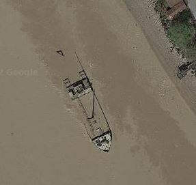
Rarely does it happen that the wreck of a ship sunk during the Second World War is still visible today. Frisco, an Italian cargo ship of 4,610 tons, was scuttled in late August, 1944 by German troops and is currently sitting in shallow water in the Gironde, making it easily visible – and easy to map.
Frisco as viewed from the shoreline. Image via Reddit
Image via Google Maps
The ship is viewable on Google Maps and other online map providers (Google seems to have the best imagery for it – see to the right). See for yourself.
Submarines were the single greatest cause of vessel sinkings during the Second World War – about 34% of the total 20,000 ships that were sunk. The Germans in their U-boats accounted for 2,955 of these vessels and collectively they totaled over 14 million tons of shipping. Less well known is the US submarine war against the Japanese. American submarines accounted for 1,994 vessels with a tonnage of 5.6 million. Further down the list was the UK who accounted for 1,625 vessel sinkings of 1.5 million tons. The Japanese, surprisingly, accounted for only 187 vessel sinkings of less than a million tons.
It is worth noting a couple of things about these numbers:
Not all ships listed in the database have a tonnage value. Records for the western Allies tend to be better and more complete and these were often the victims of German submarine attacks. Japanese records – the target of US and UK submarines in many cases – are less complete.
Many of the vessels sunk by US submarines were small vessels (less than 20 tons) including fishing vessels and small junks in use by the local population (See the records for USS Blenny, for instance).
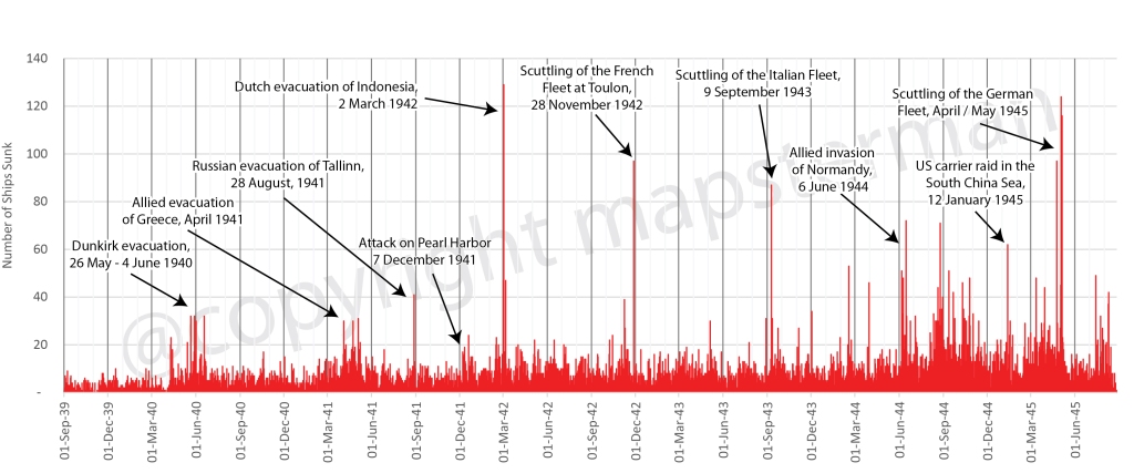
It is difficult to come up with an exact number of the ships that were sunk in the Second World War. There were at least 19,000 of all sizes with the potential for many others that have yet to be accounted for. Plotting these in a chart by the date on which they were sunk provides an interesting result and a small snapshot of the entire naval war.
An annotated chart of all the ships that were sunken in World War 2
Catastrophic events such as the evacuations of Dunkirk, Greece, Tallinn and Indonesia clearly stand out as do the scuttling of the French and Italian fleets on 28 November 1942 and 9 September 1943. But in the latter part of the war, the frequency of large numbers of ships being sunk increased so as to make singular events more difficult to pick out.
Visit the map and dashboard to get details on 14,500 of the 19,000 ships that could be mapped.
Président Dal Piaz was a 4,866 tonne Tyne built passenger / cargo ship, built and launched in 1929 for the Cie Générale Transatlantique in Marseilles, France. In 1940, after the Italian invasion of the south of France, it was taken over by the government of Italy. In 1943, it was seized by the Germans after the Italian armistice and returned to the French in February 1944. In June of that year it was again seized by the French and was intended to be used as a blockship, blocking the harbour at Cassis, France when it was torpedoed and sunk by the British submarine Universal, pretty much in the spot where the Germans had intended to scuttle her. The air photo below makes it easy to map the location of her demise.
The evacuation of the Netherlands East Indies was chaotic, as were many during the Second World War. However much they may be planned in theory, evacuations during wartime rarely go smoothly, and even when they are deemed “successful” (such as the one at Dunkirk in 1940), in the moment, chaos reigns, as the pursuing enemy disrupts events with bombing raids. Sunken ships can still be located, however. It is surprising that anyone engaged in a battle for their life might think to record the exact location of their ship’s demise, but this is what happened during the evacuation of the Netherlands East Indies, March 1 to 8, 1942.
In his book The Allied Defense of the Malay Barrier, 1941 – 1942, Tom Womack provides a detailed account of the Japanese invasion of the Netherlands East Indies. He focuses on the naval and maritime aspect of the event and provides a grim look at the scale of the Allied defeat. In just seven days, Womack writes, 186 merchant and naval vessels were scuttled as the Japanese approached Soerebaja (now called Surabaya), Batavia (Jakarta) and Tjilatjap (Cilacep) on the island of Java. The locations of 59 of these scuttled ships has been mapped; the rest received hasty descriptions, such as “at Soerebaja” or “in the Donan River.”
HMS Exeter sinking on ! March 1942 in the Java Sea Credit: Wikimedia Commons
These numbers do not include the more than 50 vessels that were sunk at sea during their attempts to escape. These locations are mostly known, as the sinkings occurred one by one at the hands of Japanese naval personnel, who recorded them in their ship logs.
One of the few wrecks that is still visible from the air, the Australian passenger / cargo ship Macdhui was sunk on June 18, 1942 after being bombed by Japanese aircraft near Port Morseby, New Guinea.