The Belgian merchant ship Bruxelles, 5,085 tons, sunk on June 9, 1942
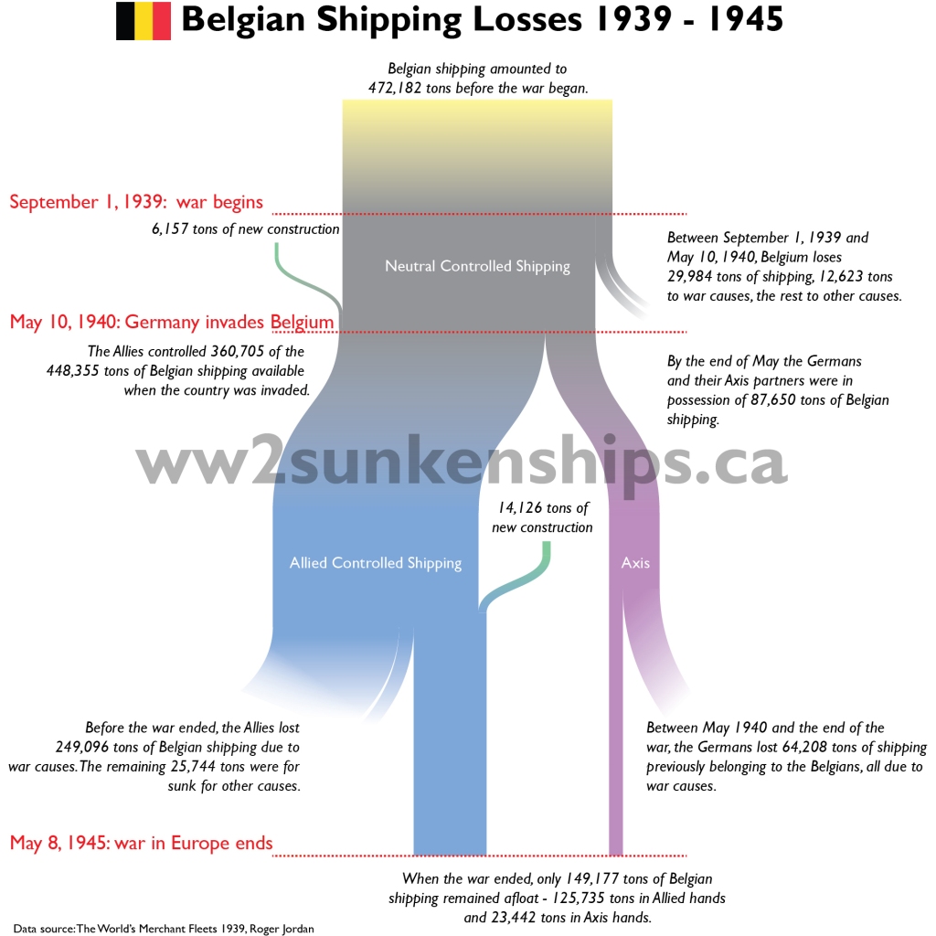
Belgium was a relatively minor player in the Second World War, both on land and on the sea. At the start of the war in September 1939, it boasted a merchant fleet of only 472,182 tons – well behind the UK, the undisputed world leader in shipping at the time with 16.6 million tons. In the period of September 1939 to May 1940 before Belgium was invaded by the Germans and the country joined the Allied cause it had already lost close 30,000 tons of shipping to accidents, mines and German torpedoes (even though it was officially neutral).
When Belgium surrendered to the Germans on May 28, 1940 only a small part of its merchant fleet fell into German hands – about 71,000 tons – while the majority – 358,000 tons – continued to serve the Allies. The Germans steadily whittled away at this disadvantage throughout the war so that by the end of the war, only about 108,000 tons of Belgian shipping in Allied control remained afloat. Of the 71,000 tons the Germans had captured, only 21,000 tons managed to survive the war. In the end, only 27% of the Belgian merchant fleet that existed at the start of the war survived to the end.
The sankey chart below provides a breakdown of the status of the Belgian fleet during the course of the war.
This 52 minute documentary sheds light why it is good to know where the sunken ships of the Second World War are. Though it grossly underestimates the number of sunken vessels as a result of that conflict (8,500 over 400 tons – in reality that number is around 12,800), it is a wonderful blend of mapping, history and environmental science that illuminates the value of my project of mapping the location of every ship sunk in the Second World War.
Much of the Germans success against Allied shipping can be rightfully attributed to their submarine fleet. Of the close to 5,000 vessels the Germans sank, 2,939 of them can be attributable to the Kriegsmarine’s submarine arm. Far behind in number but still significant are the number of ships sunk by the Luftwaffe: 1,312.
Much of this, of course, occurred in-shore along the coast of the British Isles or in the Mediterranean but the Luftwaffe did have some success with the Allies’ trans-Atlantic supply route. There the Germans employed their only long-range bomber, the 4-engined Folke-Wulf 200 Condor, with some success. With a range of 3,560 kilometres the bombers could reach out almost the middle of the Atlantic Ocean, at least at one point.
The map above shows the location of some of the 1,312 ships that were sunk by Luftwaffe aircraft. The dashed blue line indicates the approximate range of the Folke-Wulf 200. Another 413 vessels remain unmapped but most of these were in Allied harbours.
In late 1939 the German cruiser Admiral Graf Spee went on a raiding journey in the South Atlantic and sunk 9 merchant vessels before encountering the Royal Navy cruisers Exeter, Ajax and Achilles and being cornered in Montevideo, Uruguay. In the middle of this journey, Captain Langsdorff of the Admiral Graf Spee took the ship around the southern tip of Africa and sunk the Africa Shell off the coast of Mozambique before doubling back and returning to the South Atlantic., hoping to confuse his opponents and put them off the chase.
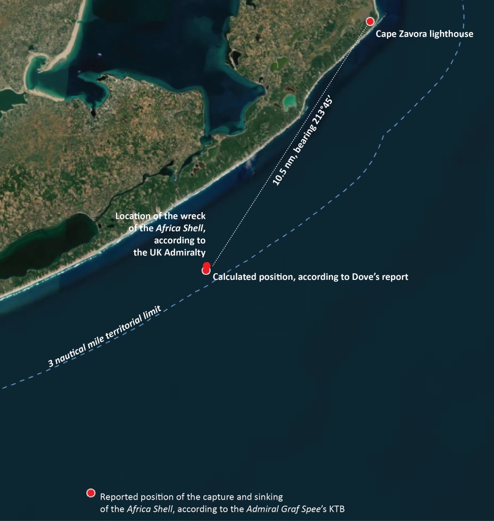
Africa Shell, a smaller tanker of 706 tons, was sighted by the Admiral Graf Spee as it was heading south along the coast for its final destination of Lourenco Marques, still some 170 nautical miles (320 kilometres) away to the southwest. According to the captain of the Africa Shell, Patrick Dove, once the Admiral Graf Spee was sighted, the Africa Shell turned to towards the shoreline in the hopes of escaping into neutral waters. Mozambique was a Portuguese colony at the time and Portugal was officially neutral.
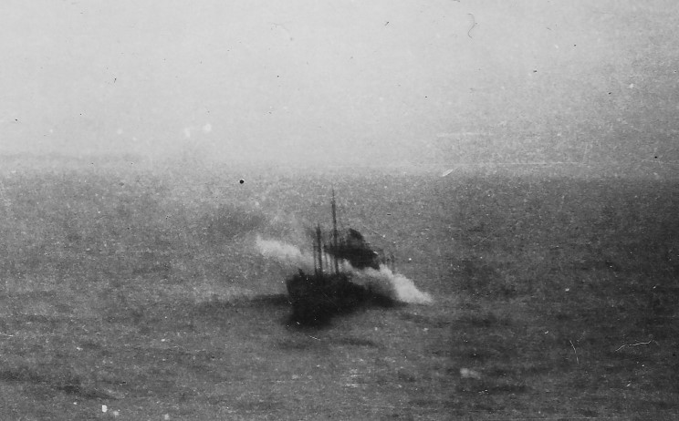
The sinking of the Africa Shell. Photo via MaritimeQuest
Dove writes in his book I Was Graf Spee’s Prisoner that his orders to his navigation officer “were to take the most careful bearings and make a full record of them on paper. I myself checked these bearings.”[1] He insists that the ship was a half mile within the 3 nautical mile limit. Elsewhere in his book he states that “according to the bearings taken by my second officer my position was ten-and-a-half miles southwest by south from Cape Zavora lighthouse, and my vessel was two-and-a-half miles from the shore, and therefore inside the territorial limits of Portuguese East Africa.”[2] The UK Admiralty’s database of wrecks and obstructions puts the location of the Africa Shell at 24° 40′ 00″ South 35° 30′ 03″ East, about 370 m from this location.
The Germans always maintained that the Africa Shell was captured and sunk outside the 3 mile nautical limit so it is no surprise that the location of these events is different in the Admiral Graf Spee’s Kriegstagebücher or war diary (KTB). There Captain Langsdorff of the Admiral Graf Spee records that on November 15, 1939 at 14:06, the Admiral Graf Spee captured and sunk the Africa Shell at 24° 48′ South, 35° 01′ East.[3] This is approximately 9.7 nautical miles (18 km) from Dove’s stated position and 8.4 nm (15.5 km) from the Mozambique shoreline.
Of course, location measurement wasn’t an exact science in 1939 as it is today with GPS units and cellphones that give you a fairly precise location. If the weather was rough or the skies overcast, it could be tough or impossible to take any reading. Even on a good day measurements using a sextant – the instrument of the time – were +/- a half mile or so. Dove and his navigator could easily have been off as might have the Admiral Graf Spee. On top of that, both parties were motivated to state the accuracy of their claim so some allowances might have been made.
To my knowledge, the exact location of the wreck of the Africa Shell has not been mapped. Doing so would go far in clarifying whether or not the ship was sunk within territorial waters. However, even if the ship was sunk within territorial waters, it would have been unlikely to have had much affect on events. The Portuguese government might have sent a letter of protest to the German government and the Germans might have at the most, made a half-hearted apology. In any case, by the time that would have happened, the Admiral Graf Spee would have long disappeared again into the South Atlantic.
[1]I Was Graf Spee’s Prisoner, Patrick Dove, Viking Press, 1956, p.93
One of the interesting things about mapping all of the ships sunk during the Second World War are the spatial and temporal patterns they make. Mapping each shipwreck provides a simple outline of coastlines but creating an animated map that steps through the entire way day by day or month by month results in a map that shows the changing fortunes of war.
The map above shows the expansion of the war from European waters as the war progresses. By late 1941 the war had become a truly world war with the Japanese attack on Pearl Harbor. The German u-boat attacks along the east coast of the US and into the Gulf of Mexico become prominent in early 1942. What amazes me every time are the sheer number of Japanese vessels sunk by the end of the war in the western Pacific.