Chaos is not good for record-keeping

The evacuation of the Netherlands East Indies was chaotic, as were many during the Second World War. However much they may be planned in theory, evacuations during wartime rarely go smoothly, and even when they are deemed “successful” (such as the one at Dunkirk in 1940), in the moment, chaos reigns, as the pursuing enemy disrupts events with bombing raids. Sunken ships can still be located, however. It is surprising that anyone engaged in a battle for their life might think to record the exact location of their ship’s demise, but this is what happened during the evacuation of the Netherlands East Indies, March 1 to 8, 1942.

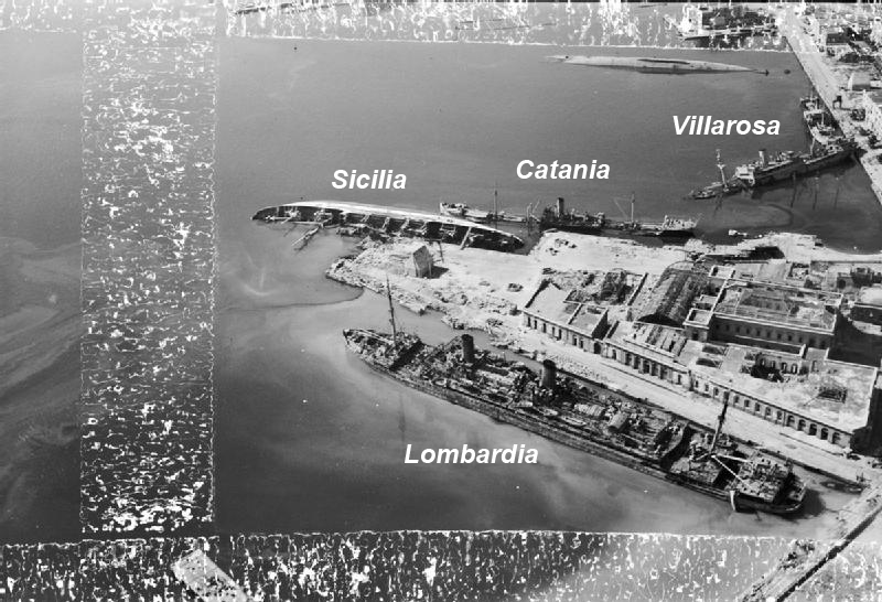
In his book The Allied Defense of the Malay Barrier, 1941 – 1942, Tom Womack provides a detailed account of the Japanese invasion of the Netherlands East Indies. He focuses on the naval and maritime aspect of the event and provides a grim look at the scale of the Allied defeat. In just seven days, Womack writes, 186 merchant and naval vessels were scuttled as the Japanese approached Soerebaja (now called Surabaya), Batavia (Jakarta) and Tjilatjap (Cilacep) on the island of Java. The locations of 59 of these scuttled ships has been mapped; the rest received hasty descriptions, such as “at Soerebaja” or “in the Donan River.” 

HMS Exeter sinking on ! March 1942 in the Java Sea
Credit: Wikimedia Commons

These numbers do not include the more than 50 vessels that were sunk at sea during their attempts to escape. These locations are mostly known, as the sinkings occurred one by one at the hands of Japanese naval personnel, who recorded them in their ship logs.

Using photos to identify & position shipwrecks

Mapping the location of shipwrecks during the Second World War can be challenging when even original data sources must be considered with some doubt. Marking the exact location of where a ship is sunk is not usually the first thing on the participants’minds during the heat of battle. This is even more so the case during moments of intense activity when numerous ships are hit.

One such example are the ships that were sunk during the various Allied air raids on Naples. The city experienced a number of air attacks between June 1940 and September 1943 when Italy surrendered The most serious and numerous of these attacks happened in the summer of 1943 so that when the city fell to the Allies in September, the harbour was littered with sunken vesels.

None of these sunken ships has been listed with an exact location but rather simply as “Naples Harbour.” A few photos exist, however, of the harbour, showing some of the wreckage. Though not all these ships are named, some are and, with careful analysis of landmarks in the photos, it is possible to get a better defined positioning of these vessels than was previously possible.

Source: Naval History and Heritage Command

This photo posted on Reddit shows some of those vessels. Pictured from left to right (according to the caption) are the vessels Villarosa (sunk September 4, 1943), Catania (August 4, 1943) and Sicilia (April 4, 1943). Mount Vesuvius appears in the background meaning that the view is looking east. Comparing the above photo to some other available aerial photos such as the one below , one can better identify the positioning of these 3 ships within the harbour.

Credit: Imperial War Museum (as posted in Wikipedia)

Numerous other photos exist of sunken ships in Naples Harbour but few of these ships are identified by name. Even in the photo above one can see a fourth sunken ship, overturned and unidentified. With these two photos one is able to get an apporixmate locations of their sinkings.

Credit: Maxar, Esri

A number of other ships that were sunk in the harbour do not yet appear on the map. To view these ships and others in the global context, visit Sunken Ships of the Second World War.

Australian Cargo Ship Macdhui

The wreck of the Macdhui (Source: Esri, Maxar)

One of the few wrecks that is still visible from the air, the Australian passenger / cargo ship Macdhui was sunk on June 18, 1942 after being bombed by Japanese aircraft near Port Morseby, New Guinea.

Tonnage: 4,561

Casualties: 10

Location: 9 26 56S 147 8 13E

For further reference: Wikipedia, Pacific Wrecks, Michael McFadyen’s Scuba Diving Web Site, PNG Attitude, WreckSite

See it in on the map.