Submarines were the single greatest cause of vessel sinkings during the Second World War – about 34% of the total 20,000 ships that were sunk. The Germans in their U-boats accounted for 2,955 of these vessels and collectively they totaled over 14 million tons of shipping. Less well known is the US submarine war against the Japanese. American submarines accounted for 1,994 vessels with a tonnage of 5.6 million. Further down the list was the UK who accounted for 1,625 vessel sinkings of 1.5 million tons. The Japanese, surprisingly, accounted for only 187 vessel sinkings of less than a million tons.
It is worth noting a couple of things about these numbers:
Not all ships listed in the database have a tonnage value. Records for the western Allies tend to be better and more complete and these were often the victims of German submarine attacks. Japanese records – the target of US and UK submarines in many cases – are less complete.
Many of the vessels sunk by US submarines were small vessels (less than 20 tons) including fishing vessels and small junks in use by the local population (See the records for USS Blenny, for instance).
The database of ships sunk during the Second World War currently contains 19,862 records, 15,025 or about 75% mapped. These ships were sunk in different ways but they can all be categorized into one of the following: submarine attack, surface vessel attack, aircraft attack, land-based attack, mines, scuttling, other means and unknown means. The breakdown is as follows:
Type of Attack
Number of Vessels Sunk
Percentage of All Vessels Sunk
Submarine
6,721
33.8%
Aircraft
5,624
28.5%
Mine
2,669
13.4%
Scuttled
2,199
11.1%
Surface Vessel
1,833
9.2%
Land-based
177
0.9%
Other
248
1.2%
Unknown
394
2.0%
Total
19,866
100.0%
Attacks by submarines, aircraft and surface vessels accounted for 71% of all the vessels sunk during the Second World War.
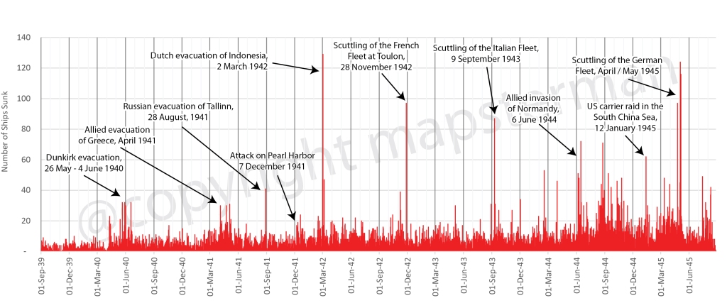
It is difficult to come up with an exact number of the ships that were sunk in the Second World War. There were at least 19,000 of all sizes with the potential for many others that have yet to be accounted for. Plotting these in a chart by the date on which they were sunk provides an interesting result and a small snapshot of the entire naval war.
An annotated chart of all the ships that were sunken in World War 2
Catastrophic events such as the evacuations of Dunkirk, Greece, Tallinn and Indonesia clearly stand out as do the scuttling of the French and Italian fleets on 28 November 1942 and 9 September 1943. But in the latter part of the war, the frequency of large numbers of ships being sunk increased so as to make singular events more difficult to pick out.
Visit the map and dashboard to get details on 14,500 of the 19,000 ships that could be mapped.
Président Dal Piaz was a 4,866 tonne Tyne built passenger / cargo ship, built and launched in 1929 for the Cie Générale Transatlantique in Marseilles, France. In 1940, after the Italian invasion of the south of France, it was taken over by the government of Italy. In 1943, it was seized by the Germans after the Italian armistice and returned to the French in February 1944. In June of that year it was again seized by the French and was intended to be used as a blockship, blocking the harbour at Cassis, France when it was torpedoed and sunk by the British submarine Universal, pretty much in the spot where the Germans had intended to scuttle her. The air photo below makes it easy to map the location of her demise.
The evacuation of the Netherlands East Indies was chaotic, as were many during the Second World War. However much they may be planned in theory, evacuations during wartime rarely go smoothly, and even when they are deemed “successful” (such as the one at Dunkirk in 1940), in the moment, chaos reigns, as the pursuing enemy disrupts events with bombing raids. Sunken ships can still be located, however. It is surprising that anyone engaged in a battle for their life might think to record the exact location of their ship’s demise, but this is what happened during the evacuation of the Netherlands East Indies, March 1 to 8, 1942.
In his book The Allied Defense of the Malay Barrier, 1941 – 1942, Tom Womack provides a detailed account of the Japanese invasion of the Netherlands East Indies. He focuses on the naval and maritime aspect of the event and provides a grim look at the scale of the Allied defeat. In just seven days, Womack writes, 186 merchant and naval vessels were scuttled as the Japanese approached Soerebaja (now called Surabaya), Batavia (Jakarta) and Tjilatjap (Cilacep) on the island of Java. The locations of 59 of these scuttled ships has been mapped; the rest received hasty descriptions, such as “at Soerebaja” or “in the Donan River.”
HMS Exeter sinking on ! March 1942 in the Java Sea Credit: Wikimedia Commons
These numbers do not include the more than 50 vessels that were sunk at sea during their attempts to escape. These locations are mostly known, as the sinkings occurred one by one at the hands of Japanese naval personnel, who recorded them in their ship logs.
Mapping the location of shipwrecks during the Second World War can be challenging when even original data sources must be considered with some doubt. Marking the exact location of where a ship is sunk is not usually the first thing on the participants’minds during the heat of battle. This is even more so the case during moments of intense activity when numerous ships are hit.
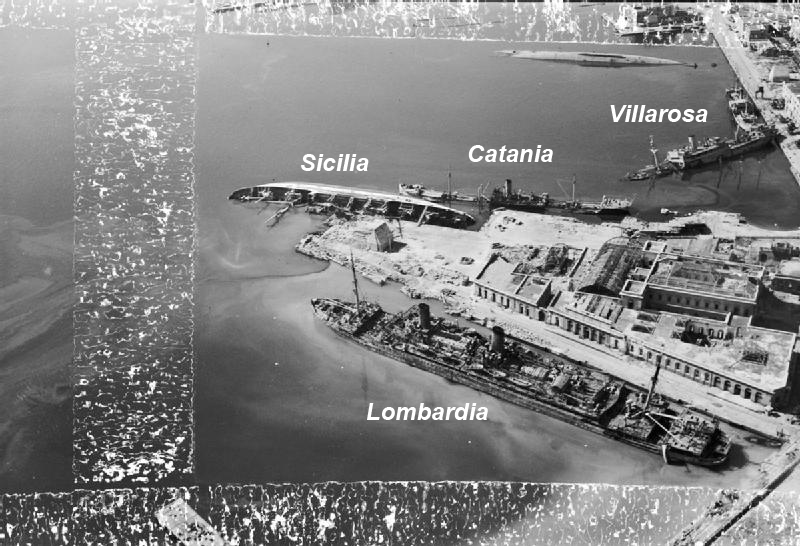
One such example are the ships that were sunk during the various Allied air raids on Naples. The city experienced a number of air attacks between June 1940 and September 1943 when Italy surrendered The most serious and numerous of these attacks happened in the summer of 1943 so that when the city fell to the Allies in September, the harbour was littered with sunken vesels.
None of these sunken ships has been listed with an exact location but rather simply as “Naples Harbour.” A few photos exist, however, of the harbour, showing some of the wreckage. Though not all these ships are named, some are and, with careful analysis of landmarks in the photos, it is possible to get a better defined positioning of these vessels than was previously possible.
This photo posted on Reddit shows some of those vessels. Pictured from left to right (according to the caption) are the vessels Villarosa (sunk September 4, 1943), Catania (August 4, 1943) and Sicilia (April 4, 1943). Mount Vesuvius appears in the background meaning that the view is looking east. Comparing the above photo to some other available aerial photos such as the one below , one can better identify the positioning of these 3 ships within the harbour.
Credit: Imperial War Museum (as posted in Wikipedia)
Numerous other photos exist of sunken ships in Naples Harbour but few of these ships are identified by name. Even in the photo above one can see a fourth sunken ship, overturned and unidentified. With these two photos one is able to get an apporixmate locations of their sinkings.
Credit: Maxar, Esri
A number of other ships that were sunk in the harbour do not yet appear on the map. To view these ships and others in the global context, visit Sunken Ships of the Second World War.
One of the few wrecks that is still visible from the air, the Australian passenger / cargo ship Macdhui was sunk on June 18, 1942 after being bombed by Japanese aircraft near Port Morseby, New Guinea.
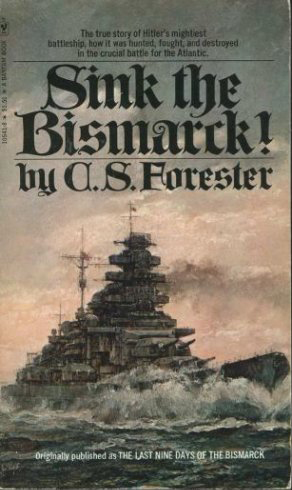
One of the books that made an impression on me as I was growing up in the 1970s was C. S. Forester’s Sink the Bismarck! Although it wasn’t the most factual account of the destruction of the the great German battleship, it did spark a life-long interest in me in Second World War naval warfare.
My other great interest while I was growing up was maps. That interest I eventually turned into a satisfying career.
Ten years ago I was surfing around the Internet and came across uboat.net, a detailed and thorough site that lists all of the ships sunk by German u-boats and their locations as well as the u-boats themselves. The site is great but the focus I found to be too limiting. U-boats played a major role in the Battle of the Atlantic but did not account for all the shipping losses in that theatre. Where were the ships sunk by mines or bombs or shells? Or, for that matter, what about the rest of the war, especially the naval war in the Pacific?
I looked about the Internet and quickly realized that no such database and/or map existed. There was a rather unsatisfactory map of World War II shipwrecks produced by SeaAustralia but it was grainy and static. Clearly, if I wanted to see such a map, I would have to create it.
And so I embarked on a project of mapping all of the ships sunk during the Second World War as a result of military action (i.e. no accidental sinkings). After 8 years of research I came up with a database and an interactive map that contained over 13,000 records. Since I published this mapping application in 2020 I have continued to research the Internet and hard copy sources for the locations of the 5,000 records for which I did not have location. This has continued to yield results and I have been able to add another 800 or so locations to the map.
Take some time with the mapping application and look up your favourite ship or location. There are bound to be mistakes so let me know if you find any.
Return to this site to learn of updates and other Second World War naval warfare maps.