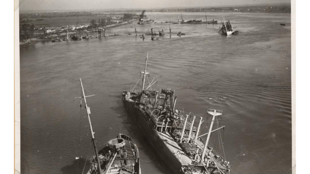
Some of the vessels sunk in the Garonne near Bordeaux in 1944
Most of the changes were tied to updated to ship sinkings around Bordeaux, France and Genoa, Italy. This is likely to be the last large update for some time.
Current total number of sunken ships mapped: 15,165
Current number of sunken ships on record but not mapped (due to no or inexact locations): 4,927
Frequently in my work I find a location for a sunken ships that is simply listed by the name of the harbour in which it sank. As the western Allies progressed on to the mainland of Europe, the Germans often sought to make whatever they left behind as useless as possible. Harbours, of course, were eminently useful to whoever had control of them and so they scuttled numerous ships in an effort to block the harbour and make any cleanup of them a long and arduous process (see Mud, Muscle, and Miracles: Marine Salvage in the United States Navy for a description of some of the challenges).
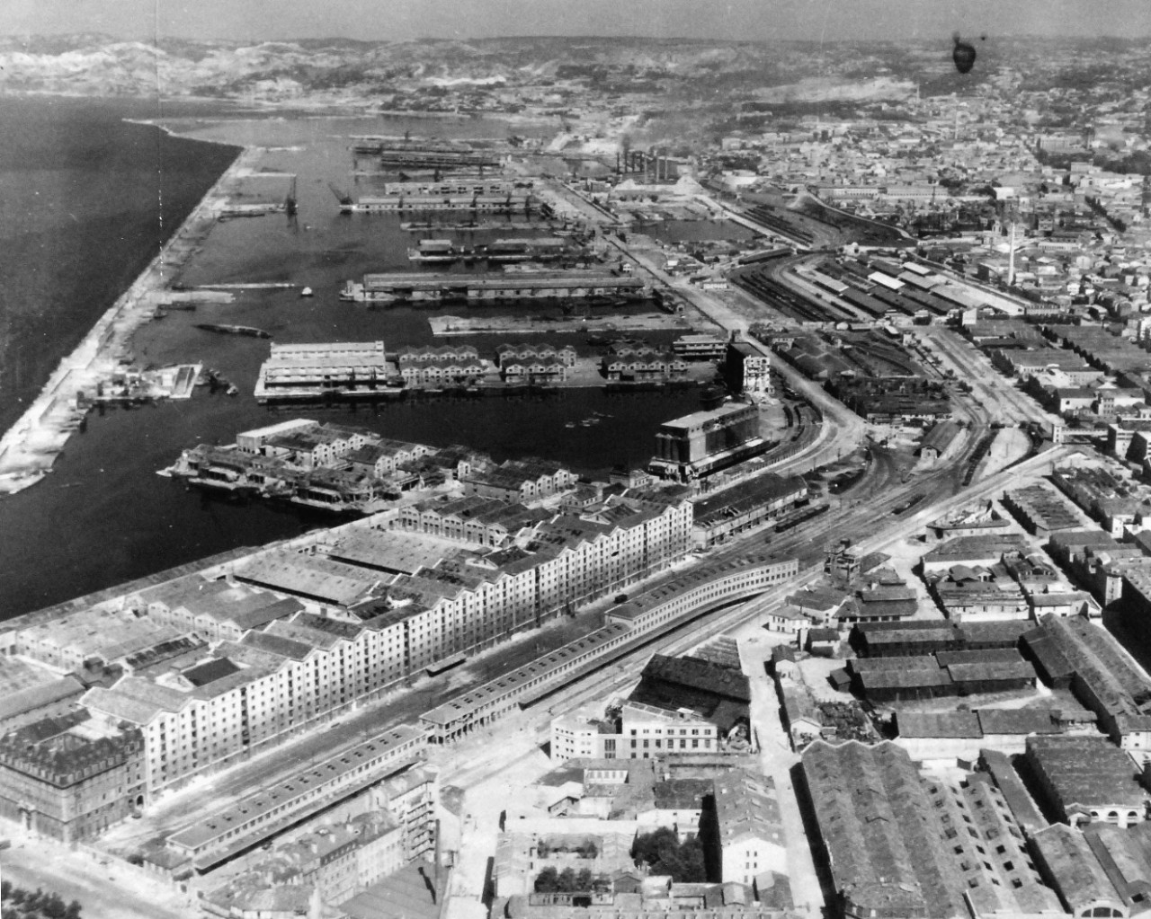
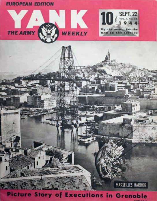
Aerial view of the harbour at Marseille, France in 1944. Note the two ships on the left-hand side of the photo (yet to be identified).
This was also the case for Marseille, France in the summer of 1944 where, according to a caption of another wrecked ship, 192 ships were wrecked (many presumably sunk). Unless there is a convenient map that displays both the names and the location of each wreck, determining the exact location for each sunken ship can be a monumental challenge.
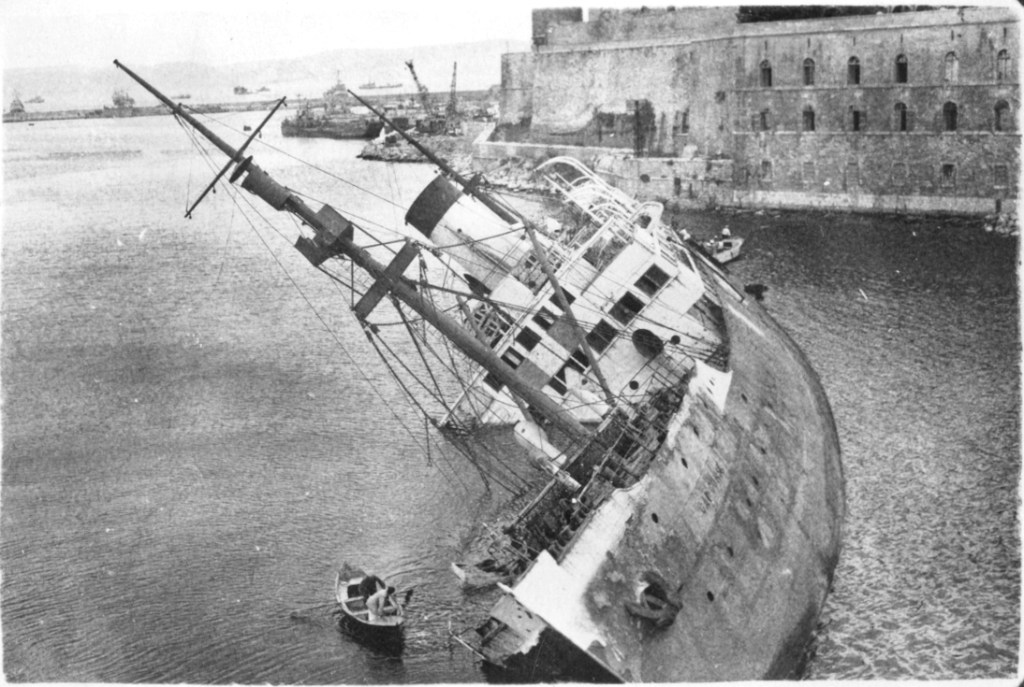
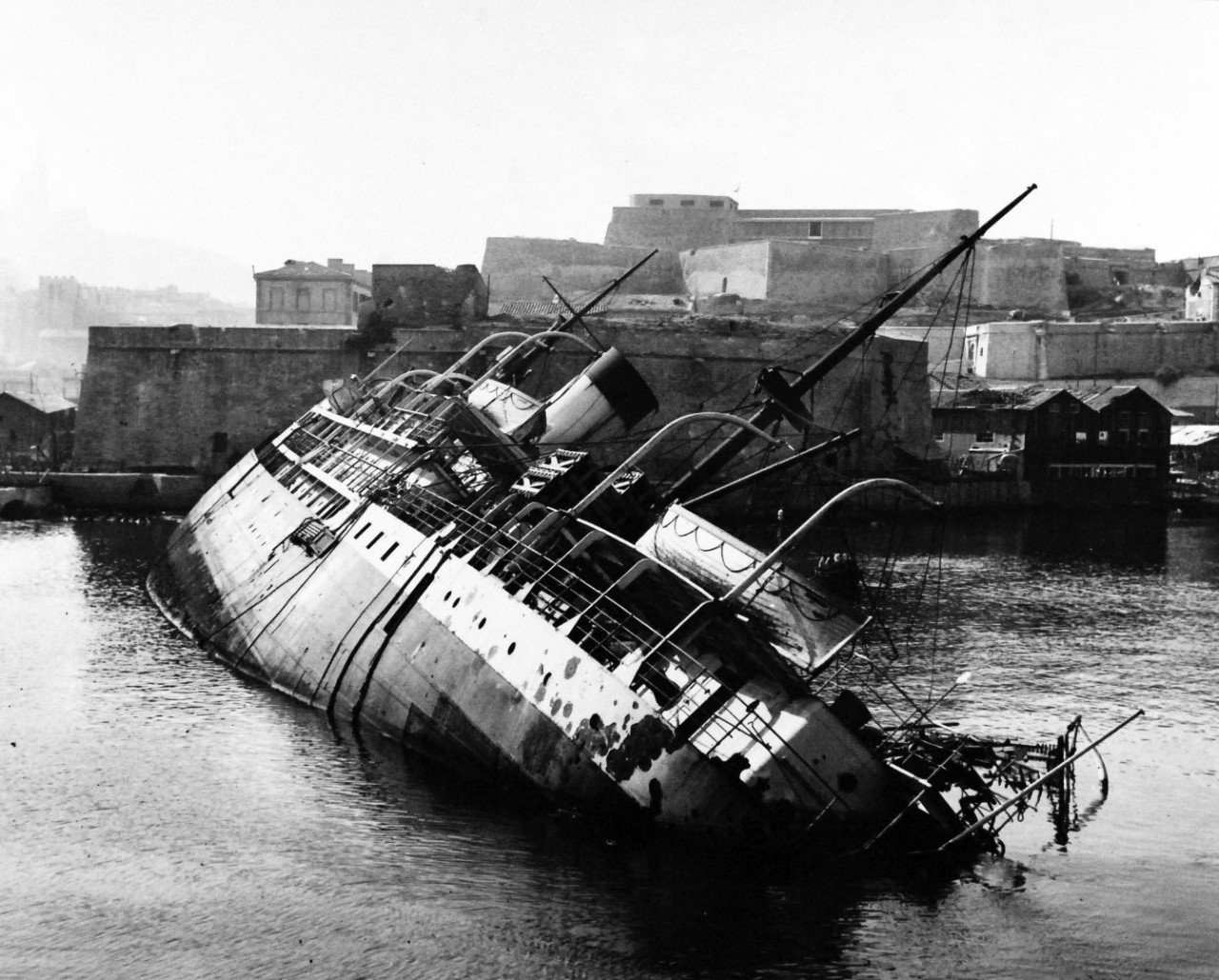
Cap Corse, a French cargo ship appropriated by the Germans during the Second World War, was scuttled by the retreating Germans at the entrance to Marseille’s old port. With a couple of strategically angled photos, it’s exact location was fairly easy to determine.
The Cap Corse on its side before Marseille’s Fort Saint Jean. Image source: Inch High Guy
I came across the image above from another blog site, Inch High Guy, where the ship is identified as the Cap Corse. Subsequently, I found other photos of the same ship from different angles to confirm the sunken ship’s resting place before it was cleared away. Below is one such photo of the same ship, but looking from the other side of the channel.
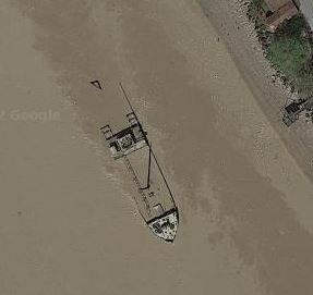
Rarely does it happen that the wreck of a ship sunk during the Second World War is still visible today. Frisco, an Italian cargo ship of 4,610 tons, was scuttled in late August, 1944 by German troops and is currently sitting in shallow water in the Gironde, making it easily visible – and easy to map.
Frisco as viewed from the shoreline. Image via Reddit
Image via Google Maps
The ship is viewable on Google Maps and other online map providers (Google seems to have the best imagery for it – see to the right). See for yourself.
Submarines were the single greatest cause of vessel sinkings during the Second World War – about 34% of the total 20,000 ships that were sunk. The Germans in their U-boats accounted for 2,955 of these vessels and collectively they totaled over 14 million tons of shipping. Less well known is the US submarine war against the Japanese. American submarines accounted for 1,994 vessels with a tonnage of 5.6 million. Further down the list was the UK who accounted for 1,625 vessel sinkings of 1.5 million tons. The Japanese, surprisingly, accounted for only 187 vessel sinkings of less than a million tons.
It is worth noting a couple of things about these numbers:
Not all ships listed in the database have a tonnage value. Records for the western Allies tend to be better and more complete and these were often the victims of German submarine attacks. Japanese records – the target of US and UK submarines in many cases – are less complete.
Many of the vessels sunk by US submarines were small vessels (less than 20 tons) including fishing vessels and small junks in use by the local population (See the records for USS Blenny, for instance).
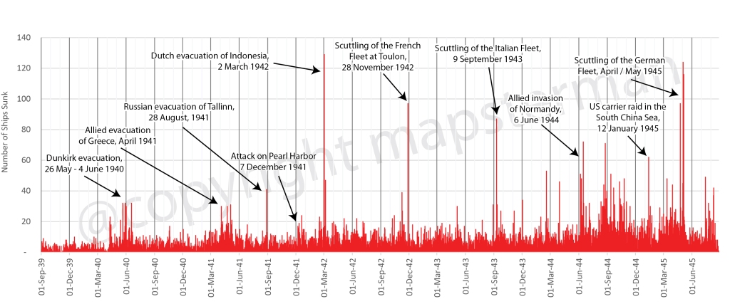
It is difficult to come up with an exact number of the ships that were sunk in the Second World War. There were at least 19,000 of all sizes with the potential for many others that have yet to be accounted for. Plotting these in a chart by the date on which they were sunk provides an interesting result and a small snapshot of the entire naval war.
An annotated chart of all the ships that were sunken in World War 2
Catastrophic events such as the evacuations of Dunkirk, Greece, Tallinn and Indonesia clearly stand out as do the scuttling of the French and Italian fleets on 28 November 1942 and 9 September 1943. But in the latter part of the war, the frequency of large numbers of ships being sunk increased so as to make singular events more difficult to pick out.
Visit the map and dashboard to get details on 14,500 of the 19,000 ships that could be mapped.
Président Dal Piaz was a 4,866 tonne Tyne built passenger / cargo ship, built and launched in 1929 for the Cie Générale Transatlantique in Marseilles, France. In 1940, after the Italian invasion of the south of France, it was taken over by the government of Italy. In 1943, it was seized by the Germans after the Italian armistice and returned to the French in February 1944. In June of that year it was again seized by the French and was intended to be used as a blockship, blocking the harbour at Cassis, France when it was torpedoed and sunk by the British submarine Universal, pretty much in the spot where the Germans had intended to scuttle her. The air photo below makes it easy to map the location of her demise.
Mapping the location of shipwrecks during the Second World War can be challenging when even original data sources must be considered with some doubt. Marking the exact location of where a ship is sunk is not usually the first thing on the participants’minds during the heat of battle. This is even more so the case during moments of intense activity when numerous ships are hit.
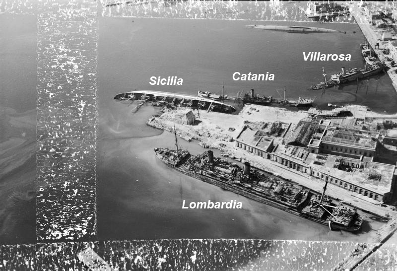
One such example are the ships that were sunk during the various Allied air raids on Naples. The city experienced a number of air attacks between June 1940 and September 1943 when Italy surrendered The most serious and numerous of these attacks happened in the summer of 1943 so that when the city fell to the Allies in September, the harbour was littered with sunken vesels.
None of these sunken ships has been listed with an exact location but rather simply as “Naples Harbour.” A few photos exist, however, of the harbour, showing some of the wreckage. Though not all these ships are named, some are and, with careful analysis of landmarks in the photos, it is possible to get a better defined positioning of these vessels than was previously possible.
This photo posted on Reddit shows some of those vessels. Pictured from left to right (according to the caption) are the vessels Villarosa (sunk September 4, 1943), Catania (August 4, 1943) and Sicilia (April 4, 1943). Mount Vesuvius appears in the background meaning that the view is looking east. Comparing the above photo to some other available aerial photos such as the one below , one can better identify the positioning of these 3 ships within the harbour.
Credit: Imperial War Museum (as posted in Wikipedia)
Numerous other photos exist of sunken ships in Naples Harbour but few of these ships are identified by name. Even in the photo above one can see a fourth sunken ship, overturned and unidentified. With these two photos one is able to get an apporixmate locations of their sinkings.
Credit: Maxar, Esri
A number of other ships that were sunk in the harbour do not yet appear on the map. To view these ships and others in the global context, visit Sunken Ships of the Second World War.