In late 1939 the German cruiser Admiral Graf Spee went on a raiding journey in the South Atlantic and sunk 9 merchant vessels before encountering the Royal Navy cruisers Exeter, Ajax and Achilles and being cornered in Montevideo, Uruguay. In the middle of this journey, Captain Langsdorff of the Admiral Graf Spee took the ship around the southern tip of Africa and sunk the Africa Shell off the coast of Mozambique before doubling back and returning to the South Atlantic., hoping to confuse his opponents and put them off the chase.
Africa Shell, a smaller tanker of 706 tons, was sighted by the Admiral Graf Spee as it was heading south along the coast for its final destination of Lourenco Marques, still some 170 nautical miles (320 kilometres) away to the southwest. According to the captain of the Africa Shell, Patrick Dove, once the Admiral Graf Spee was sighted, the Africa Shell turned to towards the shoreline in the hopes of escaping into neutral waters. Mozambique was a Portuguese colony at the time and Portugal was officially neutral.
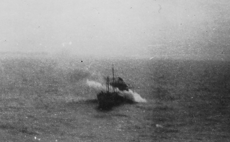
The sinking of the Africa Shell. Photo via MaritimeQuest
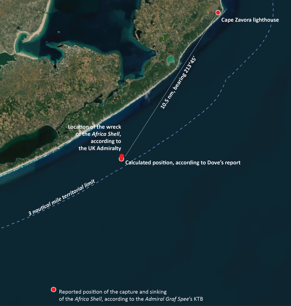
Dove writes in his book I Was Graf Spee’s Prisoner that his orders to his navigation officer “were to take the most careful bearings and make a full record of them on paper. I myself checked these bearings.”[1] He insists that the ship was a half mile within the 3 nautical mile limit. Elsewhere in his book he states that “according to the bearings taken by my second officer my position was ten-and-a-half miles southwest by south from Cape Zavora lighthouse, and my vessel was two-and-a-half miles from the shore, and therefore inside the territorial limits of Portuguese East Africa.”[2] The UK Admiralty’s database of wrecks and obstructions puts the location of the Africa Shell at 24° 40′ 00″ South 35° 30′ 03″ East, about 370 m from this location.
The Germans always maintained that the Africa Shell was captured and sunk outside the 3 mile nautical limit so it is no surprise that the location of these events is different in the Admiral Graf Spee’s Kriegstagebücher or war diary (KTB). There Captain Langsdorff of the Admiral Graf Spee records that on November 15, 1939 at 14:06, the Admiral Graf Spee captured and sunk the Africa Shell at 24° 48′ South, 35° 01′ East.[3] This is approximately 9.7 nautical miles (18 km) from Dove’s stated position and 8.4 nm (15.5 km) from the Mozambique shoreline.
Of course, location measurement wasn’t an exact science in 1939 as it is today with GPS units and cellphones that give you a fairly precise location. If the weather was rough or the skies overcast, it could be tough or impossible to take any reading. Even on a good day measurements using a sextant – the instrument of the time – were +/- a half mile or so. Dove and his navigator could easily have been off as might have the Admiral Graf Spee. On top of that, both parties were motivated to state the accuracy of their claim so some allowances might have been made.
To my knowledge, the exact location of the wreck of the Africa Shell has not been mapped. Doing so would go far in clarifying whether or not the ship was sunk within territorial waters. However, even if the ship was sunk within territorial waters, it would have been unlikely to have had much affect on events. The Portuguese government might have sent a letter of protest to the German government and the Germans might have at the most, made a half-hearted apology. In any case, by the time that would have happened, the Admiral Graf Spee would have long disappeared again into the South Atlantic.
[1]I Was Graf Spee’s Prisoner, Patrick Dove, Viking Press, 1956, p.93
One of the interesting things about mapping all of the ships sunk during the Second World War are the spatial and temporal patterns they make. Mapping each shipwreck provides a simple outline of coastlines but creating an animated map that steps through the entire way day by day or month by month results in a map that shows the changing fortunes of war.
The map above shows the expansion of the war from European waters as the war progresses. By late 1941 the war had become a truly world war with the Japanese attack on Pearl Harbor. The German u-boat attacks along the east coast of the US and into the Gulf of Mexico become prominent in early 1942. What amazes me every time are the sheer number of Japanese vessels sunk by the end of the war in the western Pacific.
I must confess: I was wrong. In last month’s update blog post I said that “These days, since I seemed to have mined most of what is available online there aren’t many changes.” Well, this month I stumbled across an entirely new source of data.
I am referring to the UK Hydrographic Office’s Admiralty Maritime Data Solutions. There they offer a shapefile of 94,000 wrecks from around the world for hundreds of years. Filtering out only those ships that were sunk between 1939 and 1945 leaves about 4,000 records. Though the wrecks can be found all around the world, the majority of the shipwrecks in the database for the time period that I am looking at are around the UK (see map), not surprisingly. I am happy to report that it appears that I have 97% of the shipwrecks on their list.
The UK Hydrographic data isn’t perfect. There are duplicate records, records putting ships well inland and a number that are listed as NameProbably? But it’s another data source and it has inspired me to dig deeper on some of the wrecks.
As a result, this month’s update is considerable:
54 additions (not all because of the UK Hydrographic list)
4 deletions (all duplicates)
387 records were moved to more accurate locations
5 other edits
I expect the next month or two to be similar as I wade through the remaining 2/3 of the data.
There were no updates to the database in November but a few in December:
3 records had edits to the date the ship sunk
5 records were moved to more accurate locations
1 new record was added
These days, since I seemed to have mined most of what is available online there aren’t many changes. But occasionally I do come across information that allows me to add in a new record. That was the case for the German corvette UJ 201 Egeria. krnicadive.com has a few shipwreck locations listed on its site, all within the Adriatic off its east coast. One of them was the Egeria. Included on the site is a detailed description of the events that led to its destruction on the last day of February, 1944. For a shortened description of the events, visit my Instagram post on the ship.
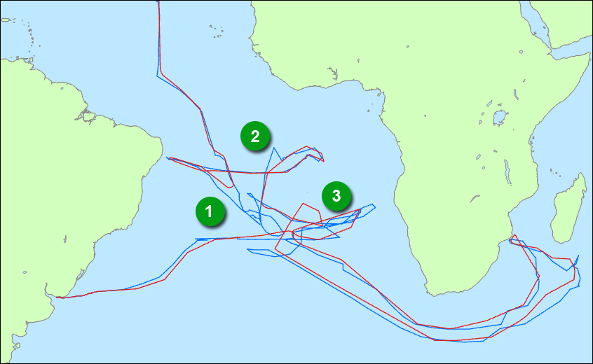
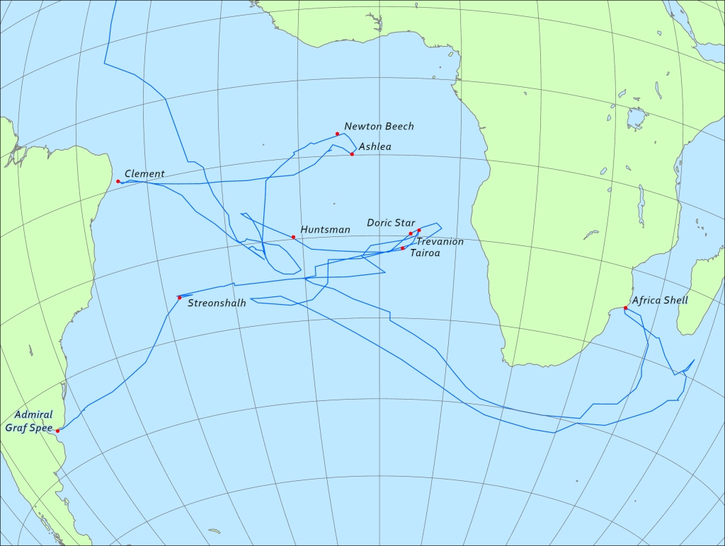
The Admiral Graf Spee, launched in 1934 was, along with the Deutschland, the first capital ship of the Kriegsmarine to venture into battle. A quick search on the Internet turns up a few route maps, most notably Roskill’s Map 11 from the first volume of his four volume The War at Sea or some version thereof (see below).
This, of course, was mapped by the Royal Navy, using Royal Navy records. But does it conform to what the Germans recorded? After all, the Admiral Graf Spee‘s war diary or Kriegstagebücheris available, albeit only in German. Nevertheless, the dates and geographic coordinates are easy to ready so let’s compare.
Admiral Graf Spee set sail from Bremerhaven, Germany on August 23, 1939 and was scuttled off Montevideo, Uruguay on December 12, 1939, 111 days. Position readings were taken twice each day, normally once at midnight and once at noon. Along with the occasional position reading taken during a significant event such as a capture or sinking of a ship, we can actually extract 232 different locations. That provides a fairly good indication of the ship’s route. With some additional mapping detail provided from the British HMSO Report on the the Battle of the River Plate, I was able to stitch together a fairly accurate map of the Admiral Graf Spee‘s voyage.
In the map below, the red lines are taken from Roskill’s Map 11, the blue lines indicate the route based on the coordinates given in the KTB. As you can see there are a few significant differences.
On Roskill’s map the 3 week period between the time the Admiral Graf Spee reached its patrol area and the time it was given the go-ahead to attack shipping towards the end of September is sketched out and marked as a waiting area with little details as to the ships movements during that period. The KTB indicates a lot of moving around in the area and this is included in the new route map.
KTB’s can easily have errors in the log and this item indicates one such possible error. The coordinate in question is from midnight on 12th of October and is listed as 7˚ 9′ S, 12˚ 25′ W. Based on the other positions from 12 hours before and after it’s more likely that the position is around 10˚9 S, 12˚25W.
Finally, as indicated with the blue lines, there was much back and forth over the same area during October 23 & 24 and again on December 2 & 3.
Add in the locations of the 9 ships that the Admiral Graf Spee sunk and the location of the ship’s own demise and we have a far more accurate map:
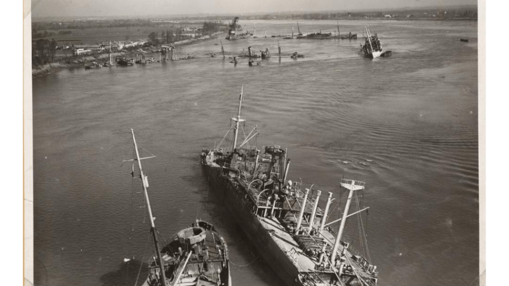
Some of the vessels sunk in the Garonne near Bordeaux in 1944
Most of the changes were tied to updated to ship sinkings around Bordeaux, France and Genoa, Italy. This is likely to be the last large update for some time.
Current total number of sunken ships mapped: 15,165
Current number of sunken ships on record but not mapped (due to no or inexact locations): 4,927
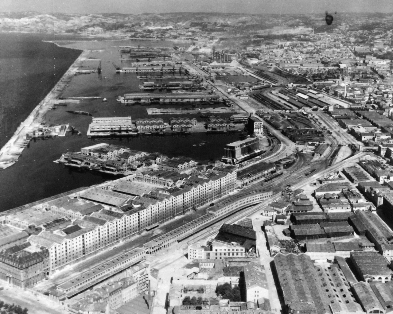
Frequently in my work I find a location for a sunken ships that is simply listed by the name of the harbour in which it sank. As the western Allies progressed on to the mainland of Europe, the Germans often sought to make whatever they left behind as useless as possible. Harbours, of course, were eminently useful to whoever had control of them and so they scuttled numerous ships in an effort to block the harbour and make any cleanup of them a long and arduous process (see Mud, Muscle, and Miracles: Marine Salvage in the United States Navy for a description of some of the challenges).
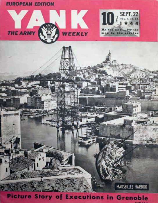
Aerial view of the harbour at Marseille, France in 1944. Note the two ships on the left-hand side of the photo (yet to be identified).
This was also the case for Marseille, France in the summer of 1944 where, according to a caption of another wrecked ship, 192 ships were wrecked (many presumably sunk). Unless there is a convenient map that displays both the names and the location of each wreck, determining the exact location for each sunken ship can be a monumental challenge.
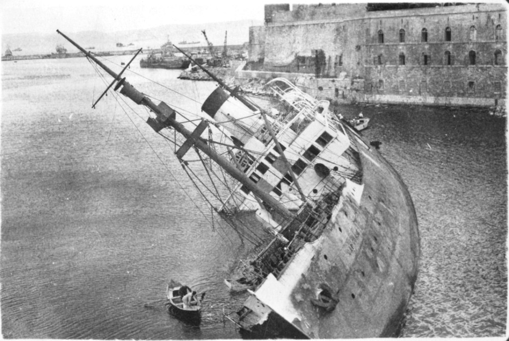
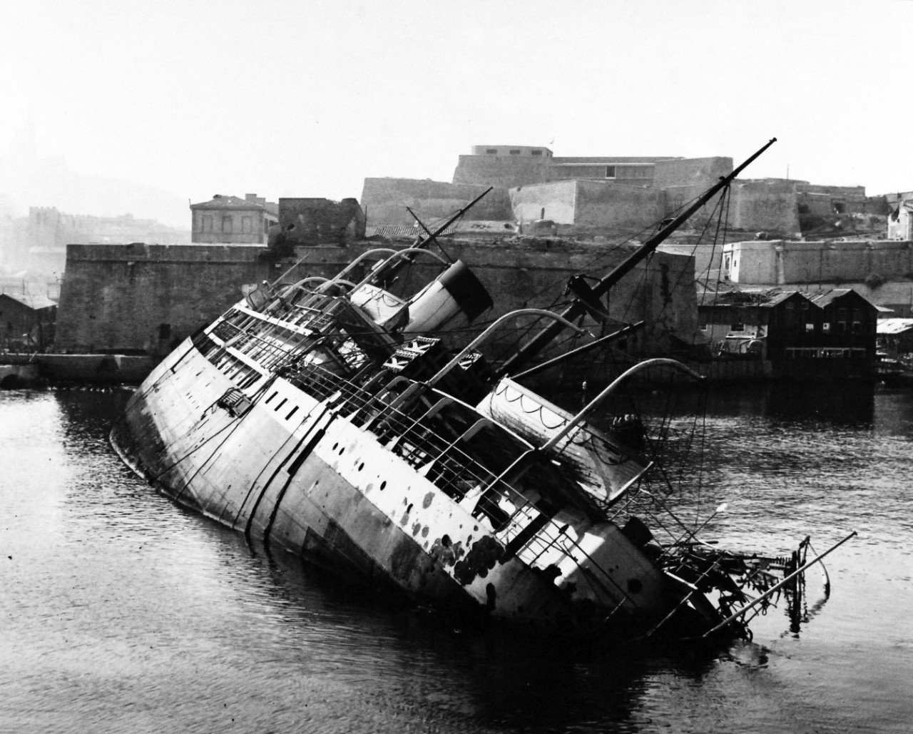
Cap Corse, a French cargo ship appropriated by the Germans during the Second World War, was scuttled by the retreating Germans at the entrance to Marseille’s old port. With a couple of strategically angled photos, it’s exact location was fairly easy to determine.
The Cap Corse on its side before Marseille’s Fort Saint Jean. Image source: Inch High Guy
I came across the image above from another blog site, Inch High Guy, where the ship is identified as the Cap Corse. Subsequently, I found other photos of the same ship from different angles to confirm the sunken ship’s resting place before it was cleared away. Below is one such photo of the same ship, but looking from the other side of the channel.
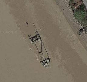
Rarely does it happen that the wreck of a ship sunk during the Second World War is still visible today. Frisco, an Italian cargo ship of 4,610 tons, was scuttled in late August, 1944 by German troops and is currently sitting in shallow water in the Gironde, making it easily visible – and easy to map.
Frisco as viewed from the shoreline. Image via Reddit
Image via Google Maps
The ship is viewable on Google Maps and other online map providers (Google seems to have the best imagery for it – see to the right). See for yourself.